Blog

Building Loci: Restorative Stewardship for Material Culture and Community Knowledge

The platform my dissertation research required.
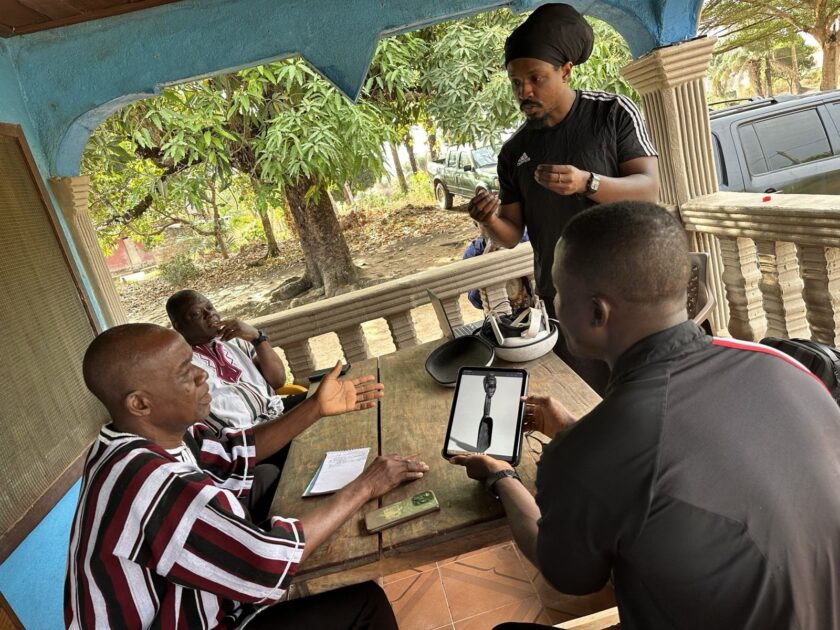
On a shaded porch in Sanniquellie, four collaborators gather around a table as one displays an archival photo of a carved spoon on a tablet; a VR headset and laptop sit nearby.

VR-based fieldwork in Sanniquellie, Liberia with colleagues from the National Museum of Liberia and the University of Liberia.


In January and February 2025, I traveled through Liberia with colleagues from the National Museum of Liberia and the University of Liberia. Our fieldwork was conducted under the banner of the Back-to-Africa Heritage and Archaeology Research Project (BAHA) through which I have worked in Liberia since 2018. 

Across eight towns and villages in three Liberian counties, we recorded virtual reality supported interpretation sessions with elders, town chiefs, spiritual leaders, artisans, and community historians. Participants encountered interactive virtual 3D models of 13 Liberian objects held in six U.S. museum and university collections. Before traveling, I used photogrammetry and structured light scanning to digitize museum-held objects. The resulting 3D models were accessed through VR headsets. With their virtual hands or controllers, participants intimately examined the art and artifacts while we recorded their memories of the objects, symbolic identifications, and culturally grounded interpretations. These sessions captured community knowledge as digital heritage data that could later circulate through the web and public platforms such as Loci. 
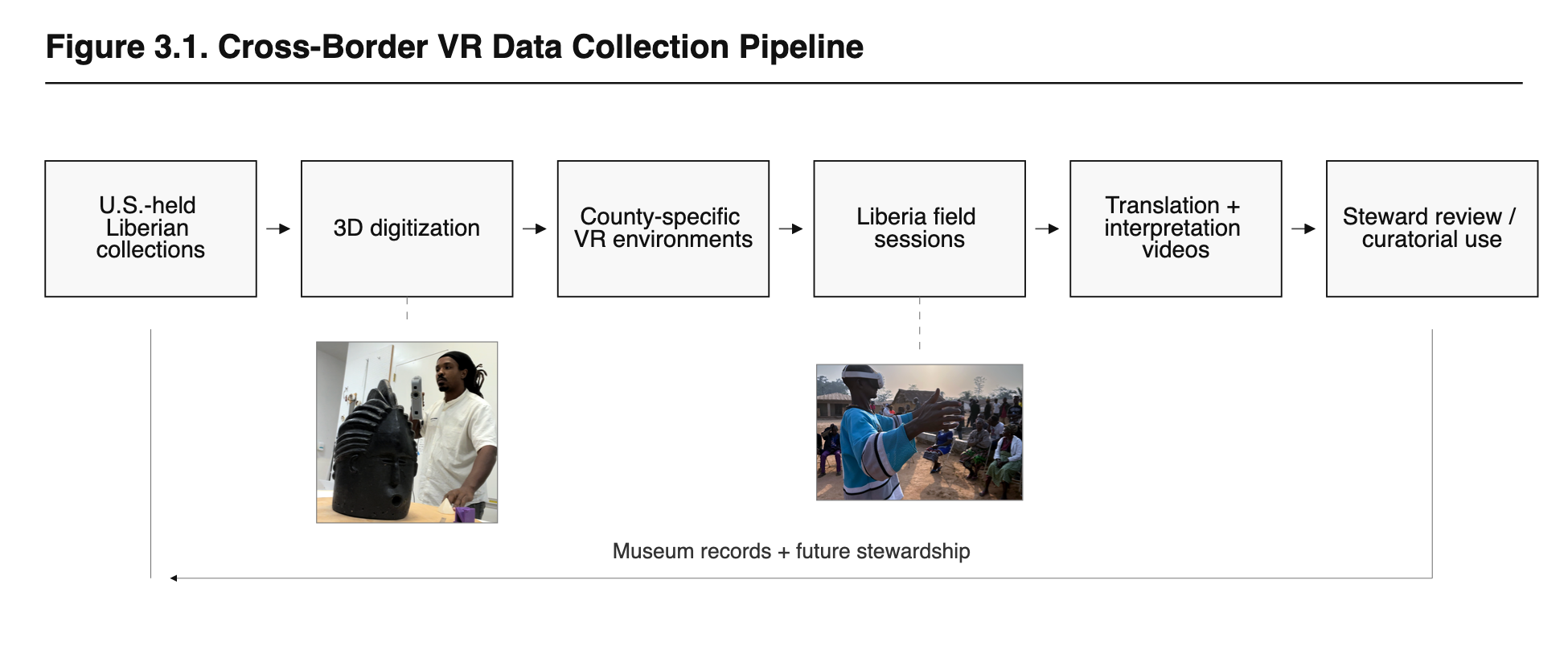
Diagram showing Liberian collections progressing through 3D digitization, county-specific VR environments, field sessions in Liberia, interpretation videos, and museum-steward review.

A cross-border digital heritage workflow connecting U.S.-held Liberian collections, 3D digitization, community interpretation in Liberia, and future museum stewardship.


The process generated an extraordinary archive of 3D models, documentary video, transcripts, and community knowledge. It also raised a practical question: Where could this material live? 

As part of my dissertation research, I surveyed collection stewards at participating museums and universities. Respondents rated the method highly for accessibility, object research, curatorial relevance, and community engagement. Readiness for integration with collection management systems received the lowest score, with a mean of 2.50 out of five. Respondents cited limited staff time, storage constraints, database compatibility, video support, IT capacity, and presentation design. One collection steward explained, “We don’t have time to fully research all of the objects.” 
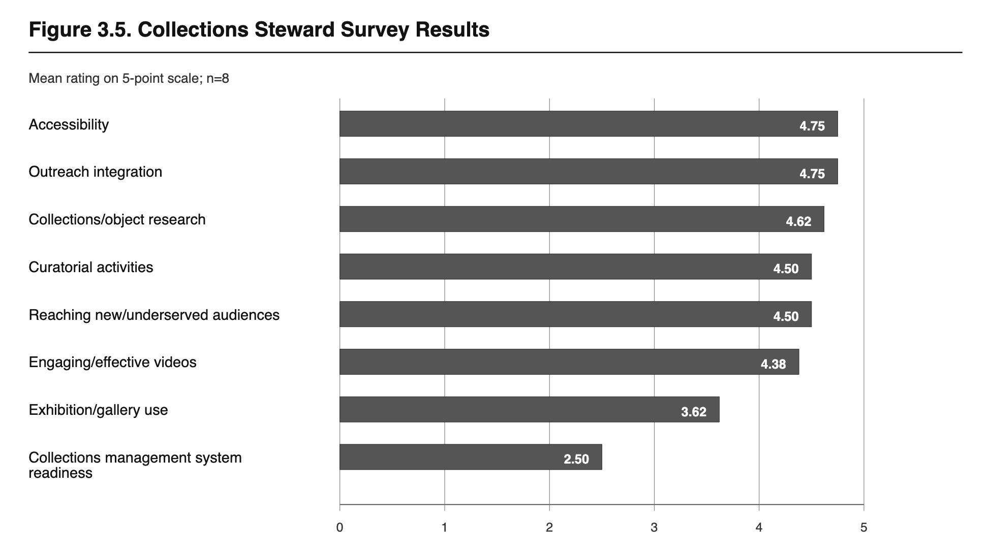
Horizontal bar chart showing mean ratings from eight collection stewards on a five-point scale: accessibility and outreach integration, 4.75; collections/object research, 4.62; curatorial activities and underserved-audience reach, 4.50; engaging videos, 4.38; exhibition use, 3.62; and collections-management-system readiness, 2.50.

Collection stewards rated the VR interpretation method highly for accessibility, outreach, research, and curatorial use. Collections-management-system readiness emerged as the clearest infrastructure gap.


The curators and institutional staff found the concept and method compelling, but the necessary digital infrastructure required further development. Loci became my response. 

Loci is an object-centered, 3D-enabled digital heritage platform that brings interactive models and recorded video interpretation into the same evidence environment. Viewers can examine an object from every angle, explore spatial annotations anchored to specific features, and connect those features to searchable transcripts and precise moments in a speaker’s testimony. Each interpretation links a named knowledge holder, an exact video segment, a transcript passage, the 3D object, and its collection context through a durable citation. This gives community knowledge an academic address. 

A user can quote Fatu V. Kamara or Lasana S. Sherif and cite the precise interpretation moment in which their grounded knowledge was shared. Community members become named intellectual authorities within the academic record. Their words can shape object research, exhibition development, classroom teaching, and future stewardship decisions. 

Explore Fatu V. Kamara’s interpretation in Loci → 
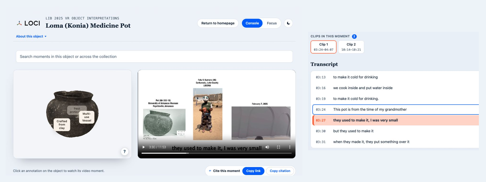
Side-by-side screenshots from Loci. The left view shows an annotated 3D model of Pot 68-300-18 beside Fatu V. Kamara’s video interpretation. The right view shows the corresponding transcript, with the 03:27 line “they used to make it, I was very small” highlighted.

Two views of the same Loci evidence page connect Fatu V. Kamara’s video interpretation with an interactive 3D model of Pot 68-300-18, spatial annotations, synchronized transcript passages, and tools for citing the precise evidence moment.


For me, restorative collection stewardship means rebuilding relationships among objects, source communities, collecting institutions, and public knowledge. Loci turns that principle into information architecture. Its current production pilot connects six collection objects with 42 interpretation clips, 18 spatial annotations, source recordings, transcript search, semantic retrieval, consent-aware attribution, and citation tools. 

As an archaeologist and curator, I entered this project with experience in photogrammetry, structured-light scanning, virtual reality, 3D production, documentary media, and digital exhibitions. Application development was a new discipline for me. During my residency in Northwestern IT’s Emerging Technologies Lab, AI coding agents like Codex and Claude gave me an accessible way to translate years of research and curatorial thinking into working software. 

I defined how objects, speakers, clips, transcripts, annotations, consent, and citations should relate. I then worked iteratively with coding agents to implement, test, inspect, and deploy those relationships. The process was exhilarating. It allowed me to move directly from a dissertation finding to a technologically sophisticated public interface shaped around the research itself. Coding agents offer archaeologists, humanists, and museum professionals a profound expansion of creative agency. Domain expertise can now guide the construction of powerful public tools. 

For Loci, that construction was intentional at every layer. React provides the public-facing browser interface, while Three.js renders interactive 3D models and anchors interpretation to specific parts of their surfaces. FastAPI connects that experience to PostgreSQL, where object records, speakers, transcripts, citations, and publication states remain structured and durable. pgvector supports semantic search, while Redis and RQ move longer-running work into the background so the interface remains responsive. FastEmbed runs on my own machine, converting transcript passages into numerical representations that help Loci recognize related ideas even when speakers use different words. A private authoring environment supports research, rights review, and curation before approved materials enter the public platform. Each component serves a curatorial purpose: reliable evidence, meaningful relationships, responsive media, and accountable publication. 

Within this stack, FFmpeg became one of my favorite open-source tools. Created by Fabrice Bellard around 2000 and sustained by a global community, FFmpeg supplies much of the invisible machinery of internet video. In Loci, it converts recordings from different cameras and field settings into consistent, web-ready media, generates precise excerpts and thumbnails, and preserves the timing that connects a speaker’s words to transcripts, citations, and 3D annotations. A recent Lex Fridman conversation with Jean-Baptiste Kempf and Kieran Kunhya captures the ingenuity and generosity behind this work. FFmpeg and Three.js showed me how open-source technical commons expand what coding agents can accomplish. As an archaeologist and curator without a computer science background, I used those agents to understand, integrate, test, and adapt mature tools for a specific heritage mission. Their established foundations gave me the leverage to concentrate on the platform’s cultural and scholarly architecture. Loci grew from that convergence of domain expertise, agent-assisted development, and gratitude toward the public technical commons. 

I will continue this work in my new position as an assistant professor in the Department of African and African Diaspora Studies at the University of Texas at Austin. I plan to teach students to wield AI coding agents alongside virtual reality, augmented reality, 3D digitization, photogrammetry, and motion capture. Together, we will explore how these technologies can document cultural traditions, investigate humanistic questions, and create resources that serve communities and public audiences. 

Austin’s cultural landscape and collections across the United States will provide new opportunities to expand Loci. Students will help develop pathways for connecting material culture with the voices, likenesses, and epistemologies of the people who know it deeply. 

Loci began as the platform my research required. Its future lies in helping communities, students, scholars, and collection stewards build a more connected and citable heritage record. 
Augmented Curiosities: An XR Exhibition with the Herskovits Library of African Studies

Augmented Curiosities: Virtual Play in African Pasts and Futures is an immersive exhibition that places African material culture in the hands of its visitors. As an Innovator-in-Residence for Media Technology & Innovation, I developed the project through collaborations with the Northwestern University Library, most specifically the Melville J. Herskovits Library of African Studies, and Northwestern IT. Augmented Curiosities is designed to promote the Herskovits’ incredible object collection and provoke conversations about the use of Virtual Reality (VR) and Augmented Reality (AR) within the storytelling strategies of museums.

I’m an archaeologist and a curator. Within these disciplines, I use material-based methods to explore my interests in expressive and tangible culture as a force of preservation – especially within cultures that do not rely upon the written record. Archaeologists understand that objects and artifacts often embody characteristics of the people and processes that created them. Craftspeople, artists and producers of many practices embed their unique perspectives within the fabric of their works. The energy of an individual, community or landscape can often be gleaned from the materials it produces. Because of this, we curators often use objects to tell stories of the human past and widen an audience’s capacity for imagination. I’m particularly interested in widening imaginations about African pasts and futures. And curation provides me intellectual space to produce scholarship as an artist within an archaeological practice. I work to engage that artistry through experimentation with technology and digital media. Augmented Curiosities is my most recent effort towards that end.

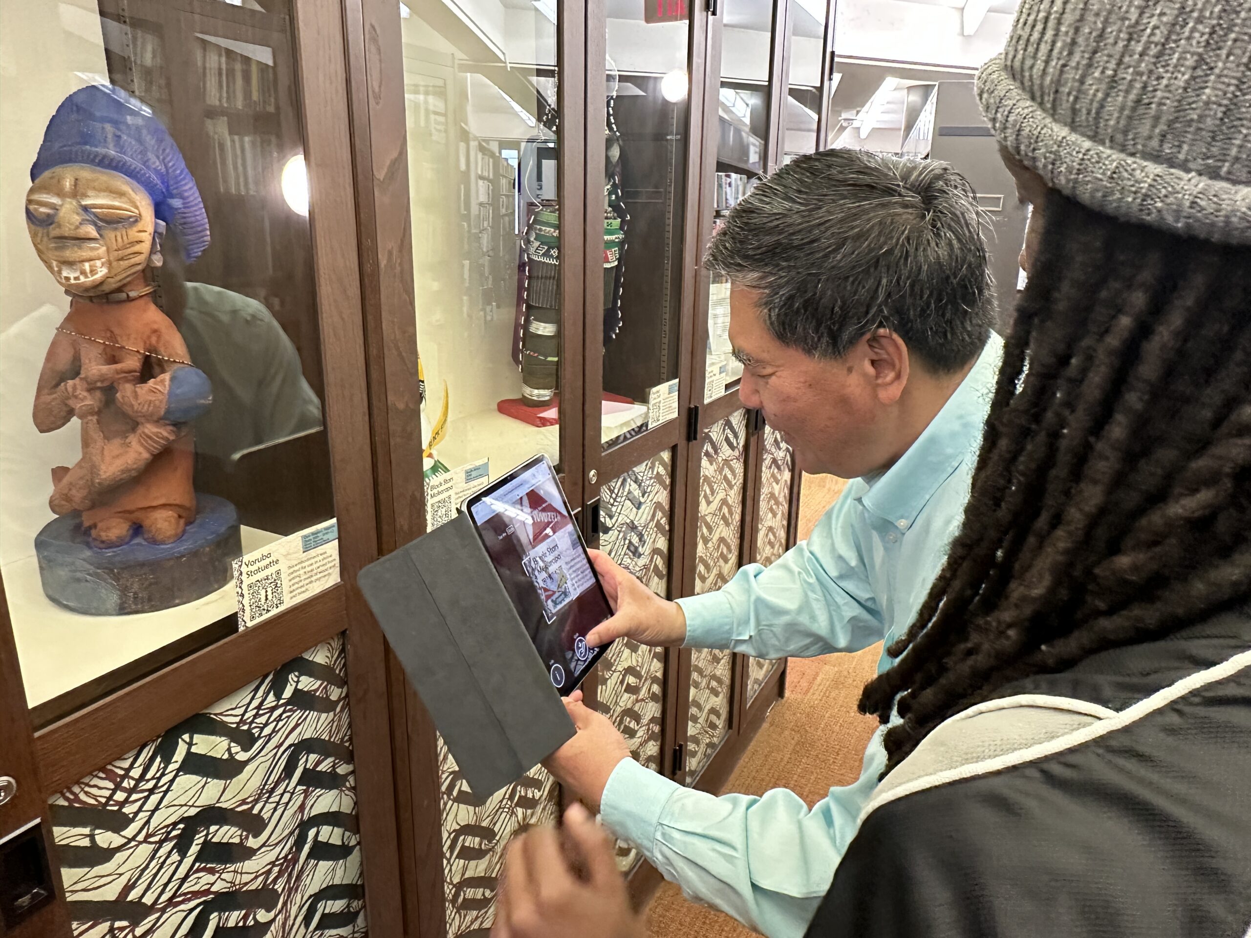
For this project, I sought to find ways to place fragile, valuable or otherwise inaccessible objects from the Herskovits Library of African Studies collection into the hands of visitors. To accomplish this, our team integrated Virtual Reality and Augmented Reality experiences within an exhibition, that allowed visitors to intimately engage the objects. We used photogrammetry and 3D modeling to create a digital replica of each object and the exhibition cabinet in which they are housed. We then made those replicas accessible through the development of a VR application in Unity Game Engine and a web AR experience through the 8thwall platform. This curatorial framework allowed me to express historical, archaeological and anthropological data as time, space and experience. The VR and AR content delivery strategies offer visitors an immersive experience in which they may virtually remove the objects out of the glass-paned exhibition cabinet and play with them. Through this we created a product that was both educational and entertaining – simultaneously exhibiting emerging technologies and relatively hidden objects.

Northwestern University Dean of Libraries, Xuemao Wang, trying out the Augmented Reality Experience
Augmented Curiosities was partly inspired by my interest in affective curation. I believe objects possess energy that humans transform into meaning. We deploy our personalities, emotions and unique lived experiences to make sense of our physical surroundings. I want to curate this phenomenon. Rather than highlighting geographic origins or manufacture dates, I am far more interested in allowing a visitor to have experiences with material culture. I sought to exhibit the feeling of the objects as opposed to prescribing their meanings. To archive this within the exhibition, we produced video interviews from Northwestern University community members that contextualize each object within emotional, political, spiritual and familial landscapes. Interviewees were prompted to respond to the question: “What does this object mean to you and how does it make you feel?” The videos of their testimonies create an atmosphere of intimacy as visitors explore within the VR experience. Affective curation allows me to invert some of the power dynamics of exhibition development, delegating parts of the knowledge-production process to the communities that the exhibition engages. I am eager to further develop this theory and methodology throughout my career.

This experience affirmed for me the expansive opportunities offered by digital curation. The Augmented Curiosities project facilitated the production of a new archive – consisting of 3D models, video, audio and literature. The project created and consolidated a dynamic range of new and existing resources that support cursory browsing or rabbit-hole deep dives into the objects, communities and research that constitute the exhibition. Following the guidance of Esmeralda Kale, the curator of the Herskovits Library of African Studies, I created an Augmented Curiosities LibGuide which preserves the exhibition within the Northwestern University Library database. It is my hope that this rootedness within the digital infrastructure of the Library will encourage further inclusion of digital resources, such as 3D models and expert testimonies, within the University’s digital repositories.

Augmented Curiosities is the product of ambitious ideation and incredible institutional support. An expanse of Northwestern University units contributed time, expertise and funding to produce this unprecedented exhibition. I am grateful and indebted to the talented group of developers, engineers, scholars and technicians that believed in my idea and assisted its creation. Augmented Curiosities is a testament to the worthiness of interdisciplinary research and the ease in which meaningful cross-campus collaboration can occur at Northwestern University.

Personally, this project has been a tremendous success. I tested hypotheses, gained methodological training, developed theory and shared a product of the process with the Northwestern University community – an exemplary graduate student research experience that I’m extremely grateful for. Ultimately, it is my hope that Augmented Curiosities makes evident the power of immersive visualization techniques and encourages visitors to critically reflect upon the value proposition of exhibitions and the museum industry.

Unearthing History from the Skies: Northwestern’s Drone Lab Experience

written by: Craig Stevens, Eli Kuto and Nate Bartlett

In our mission to promote the use of emerging technologies for the Northwestern University community, Media and Technology Innovation (MTI) partnered with the Anthropology Department to bring innovation to the forefront of the classroom. Anthropology Doctoral Students Craig Stevens and Eli Kuto, alongside Nate Bartlett and the MTI team, joined forces to create an unforgettable lab experience for students in the Fall 2023 term Archaeology: Unearthing History (214-0-1) course.

Powered by the whirr of drone propellers and the magic of 3D photogrammetry, we embarked on a mission to unearth the history of our very own campus landscape. In the hands of intrepid anthropology students, our Unmanned Aerial Systems (UAS) weren’t just delivering pizza, they were investigating the history of Northwestern’s iconic Lakefill and capturing the intricate tapestry of the landscape below.

Lab participants waving for aerial drone photograph
Dr. Rozensweig (Anthropology), Nate Bartlett (MTI), Eli Kuto (Anthropology), Craig Stevens (MTI), and ANTH 214 lab section participants waving for an aerial drone photograph.

With the leadership of course instructor Dr. Melissa Rozensweig, the MTI team set out to explore how to integrate the technology in ways that were safe and accessible for students while also figuring out the logisitics of doing this kind of activity with a large-enrollment class. Through consultation and collaboration with the NU Environmental Health and Safety Department (EHS), an extra layer of security was added to our high-flying endeavors.

Our team sought to create a hands-on exploration that highlighted the transformative power of technology in understanding landscapes. To accomplish this, participating students operated a drone in supervised missions, flying gridded patterns over the Lakefill landscape. As preparation, each student read and acknowledged an MTI-crafted safety acknowledgment form – provoking a touch of excitement and responsibility, ensuring students were mentally prepared for their airborne missions.

Over four days, 77 Northwestern students launched a drone from the North lawn of the Norris University Center, investigating and documenting the Northwestern University Lakefill from hundreds of feet above the ground. Their mission was to unravel the historic formation of the campus landscape, using cutting-edge technology to explore the past from an immersive bird’s-eye view.

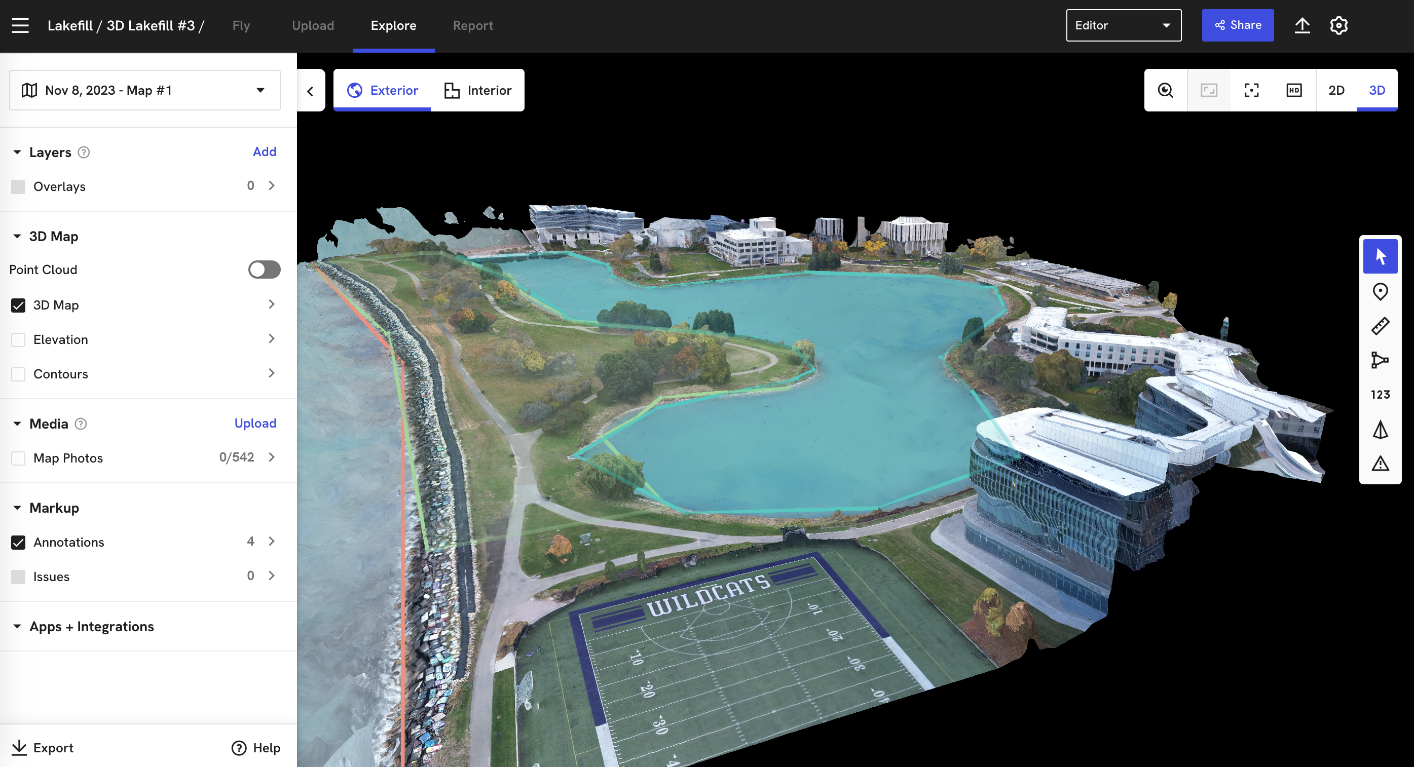
Guided by key questions on visibility, proximity, accessibility, location, context, and significance, students analyzed a 3D model of the Lakefill, which was made possible by our week-long aerial data collection. The aerial perspective prompted students to contemplate changes, both subtle and profound, in the Northwestern Lakefill and Lagoon. Students compared pre-Lakefill maps with present-day 3D models, witnessing vanished shorelines and the emergence of an innovative architectural marvel. They traced the veins of paths and sidewalks, wondering about the students of the past that once traversed them. This wasn’t just about studying history – it was about feeling its pulse. More than a demonstration of technology, we collaboratively designed a lesson in human-environment relationships and the impact of anthropogenic factors on landscapes. From above, the familiar campus transformed into a living, breathing timeline. And the sculpted earth revealed the fingerprints of human intervention.

screenshot of lakefill 3D model in droneedeploy software
A screenshot of the Lakefill and Lagoon 3D model in the DroneDeploy web interface.

The impact of this lab experience went beyond the classroom. Students didn’t just analyze the Lakefill – they reported on it, creating detailed accounts of its formation and evolution. For homework, students produced a landscape formation report based on their analysis of the 3D models, providing a unique and insightful perspective on the Northwestern Lakefill. Check out some of their enlightening takeaways:

Student A: “From the aerial and 3D view of the Lakefill and lagoon, a lot of the Lakefill area and a significant chunk of campus can be seen through different angles. The aerial view is significant as it can help you judge distance and acreage, elevation levels, plant heights, etc”.

Student B: “The 3D model of the Lakefill emphasizes the man-made lagoon, as the model does not include the entirety of the Lakefill. You gain a clear picture of the density of the foliage, the landscape design of the land near the lagoon, and information on the buildings closest to the lagoon. The aerial view emphasizes the shape of the Lagoon, and its sheer size, marking it as a dominant part of the Lakefill”

Student C: “The aerial view of the landscape provides a detailed overhead view. Using an aerial view displays visibility that is not possible to see from field walking or ground survey. The 3D model centers around the Lakefill and provides imaging of the surrounding landscape”.

Our team was delighted by the first-hand and original analyses of our campus that the students contributed. The lab experience became a pedagogical innovation for Northwestern, showcasing the potential of technology to make education entertaining and impactful.

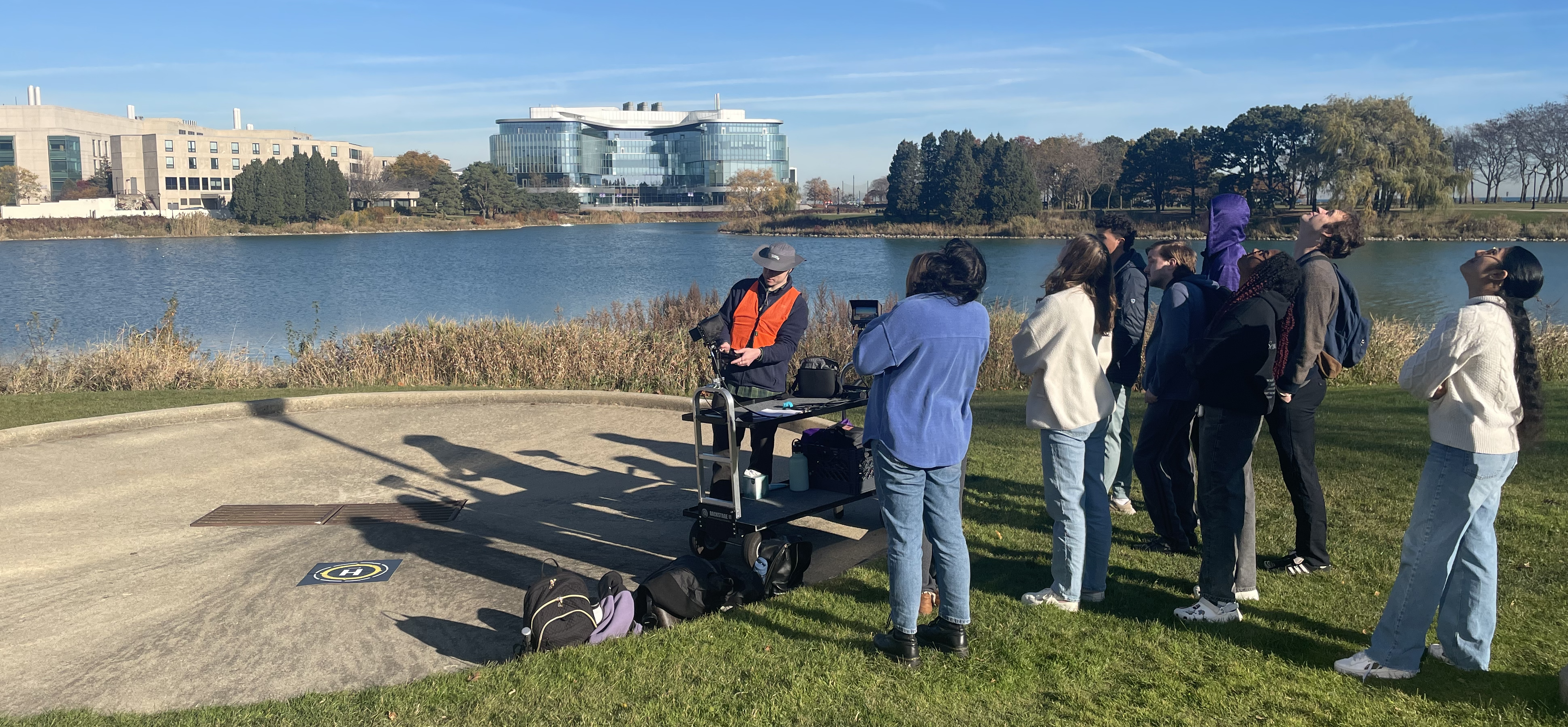
Lab participants looking up spotting a drone after launch.
Lab participants spotting the drone after the instructional launch.

The collaboration with the Anthropology department is set to continue, with plans in the works to regularly offer this lab activity for the Archaeology: Unearthing History course. Moreover, there is a commitment to finding ways to integrate digital technologies into other course topics, expanding the horizons of archaeological survey and activity areas analysis.

Through this, the ripples of our experiment extended far beyond the Lakefill. Looking ahead, the future holds exciting prospects. Students will have the opportunity to deepen their analytical skills, explore cutting-edge equipment, and delve into the dynamic relationship between technology, data collection, and analysis. As we reflect on the lessons learned, the Media and Technology Innovation team gained valuable insights into student engagement and reaffirmed the potential of drone survey strategies in education and historic preservation.

This rewarding collaboration has allowed the Media and Technology Innovation team to demonstrate the usefulness of emerging technologies for the benefit of Northwestern students, staff, and faculty. As we soar into the future of virtual and immersive experience, we hope this lab experience will be a beacon of inspiration for other departments across the campus to embrace technology and provide dynamic, entertaining and educational experiences for our incredible learning communities.

MTI Virtual Reality Exhibition # 1

This Spring, as the Innovator-In-Residence for Media & Technology Innovation (MTI), I curated our first virtual reality (VR) exhibition in the...
Read More

360 VR in the Classroom

  The Emerging Technologies Lab in collaboration with Kellogg School of Management had the opportunity to record a 360 video tour...
Read More

Creative Futures of Generative AI

In September of 2022, nearly two years after its launch, OpenAI made their flagship AI image generation platform Dall-E available to...
Read More

Photogrammetry of a Shiny Object

Photogrammetry is the process of taking multiple images of an object, and processing the images with a computer, in order to...
Read More

Look Your Best Recording Remotely

Prior to the pandemic, our team often recorded on-location or in our studio, using our own cameras and lighting equipment. In...
Read More

2019 Leopold Lecture with Rep. Adam Schiff

Addressing a full audience last night in Cahn Auditorium, California Rep. Adam Schiff, Chairman of the House Intelligence Committee, delivered this...
Read More

Class of 2023 and Transfers Aerial Photo

Welcome Class of 2023 and Transfer Students! Last Friday we were delighted to join about 2000 wildcats to create this year’s...
Read More

Robotics Filming in Tech

Last week, we filmed in the new Robotics and Biosystems Center space in the new AB Fill in Tech, interviewing faculty...
Read More

Media & Technology Innovation at Commencement 2019

Northwestern hosted its 161st annual Commencement this past weekend. Working with the Commencement Office and TC Furlong, Northwestern IT provided a...
Read More