
written by: Craig Stevens, Eli Kuto and Nate Bartlett
In our mission to promote the use of emerging technologies for the Northwestern University community, Media and Technology Innovation (MTI) partnered with the Anthropology Department to bring innovation to the forefront of the classroom. Anthropology Doctoral Students Craig Stevens and Eli Kuto, alongside Nate Bartlett and the MTI team, joined forces to create an unforgettable lab experience for students in the Fall 2023 term Archaeology: Unearthing History (214-0-1) course.
Powered by the whirr of drone propellers and the magic of 3D photogrammetry, we embarked on a mission to unearth the history of our very own campus landscape. In the hands of intrepid anthropology students, our Unmanned Aerial Systems (UAS) weren’t just delivering pizza, they were investigating the history of Northwestern’s iconic Lakefill and capturing the intricate tapestry of the landscape below.
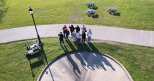
Dr. Rozensweig (Anthropology), Nate Bartlett (MTI), Eli Kuto (Anthropology), Craig Stevens (MTI), and ANTH 214 lab section participants waving for an aerial drone photograph.
With the leadership of course instructor Dr. Melissa Rozensweig, the MTI team set out to explore how to integrate the technology in ways that were safe and accessible for students while also figuring out the logisitics of doing this kind of activity with a large-enrollment class. Through consultation and collaboration with the NU Environmental Health and Safety Department (EHS), an extra layer of security was added to our high-flying endeavors.
Our team sought to create a hands-on exploration that highlighted the transformative power of technology in understanding landscapes. To accomplish this, participating students operated a drone in supervised missions, flying gridded patterns over the Lakefill landscape. As preparation, each student read and acknowledged an MTI-crafted safety acknowledgment form – provoking a touch of excitement and responsibility, ensuring students were mentally prepared for their airborne missions.
Over four days, 77 Northwestern students launched a drone from the North lawn of the Norris University Center, investigating and documenting the Northwestern University Lakefill from hundreds of feet above the ground. Their mission was to unravel the historic formation of the campus landscape, using cutting-edge technology to explore the past from an immersive bird’s-eye view.
Guided by key questions on visibility, proximity, accessibility, location, context, and significance, students analyzed a 3D model of the Lakefill, which was made possible by our week-long aerial data collection. The aerial perspective prompted students to contemplate changes, both subtle and profound, in the Northwestern Lakefill and Lagoon. Students compared pre-Lakefill maps with present-day 3D models, witnessing vanished shorelines and the emergence of an innovative architectural marvel. They traced the veins of paths and sidewalks, wondering about the students of the past that once traversed them. This wasn’t just about studying history – it was about feeling its pulse. More than a demonstration of technology, we collaboratively designed a lesson in human-environment relationships and the impact of anthropogenic factors on landscapes. From above, the familiar campus transformed into a living, breathing timeline. And the sculpted earth revealed the fingerprints of human intervention.
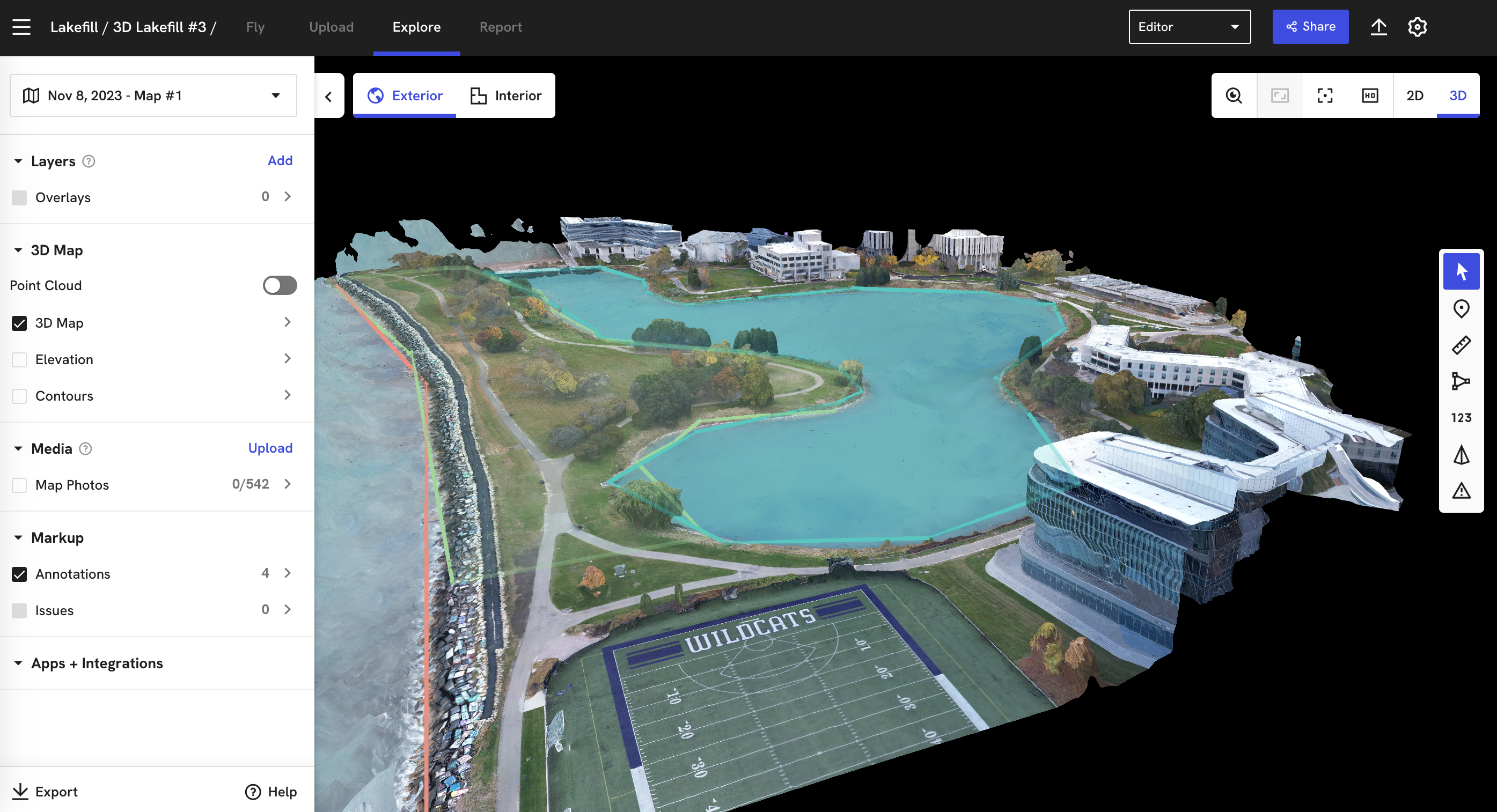
A screenshot of the Lakefill and Lagoon 3D model in the DroneDeploy web interface.
The impact of this lab experience went beyond the classroom. Students didn’t just analyze the Lakefill – they reported on it, creating detailed accounts of its formation and evolution. For homework, students produced a landscape formation report based on their analysis of the 3D models, providing a unique and insightful perspective on the Northwestern Lakefill. Check out some of their enlightening takeaways:
Student A: “From the aerial and 3D view of the Lakefill and lagoon, a lot of the Lakefill area and a significant chunk of campus can be seen through different angles. The aerial view is significant as it can help you judge distance and acreage, elevation levels, plant heights, etc”.
Student B: “The 3D model of the Lakefill emphasizes the man-made lagoon, as the model does not include the entirety of the Lakefill. You gain a clear picture of the density of the foliage, the landscape design of the land near the lagoon, and information on the buildings closest to the lagoon. The aerial view emphasizes the shape of the Lagoon, and its sheer size, marking it as a dominant part of the Lakefill”
Student C: “The aerial view of the landscape provides a detailed overhead view. Using an aerial view displays visibility that is not possible to see from field walking or ground survey. The 3D model centers around the Lakefill and provides imaging of the surrounding landscape”.
Our team was delighted by the first-hand and original analyses of our campus that the students contributed. The lab experience became a pedagogical innovation for Northwestern, showcasing the potential of technology to make education entertaining and impactful.
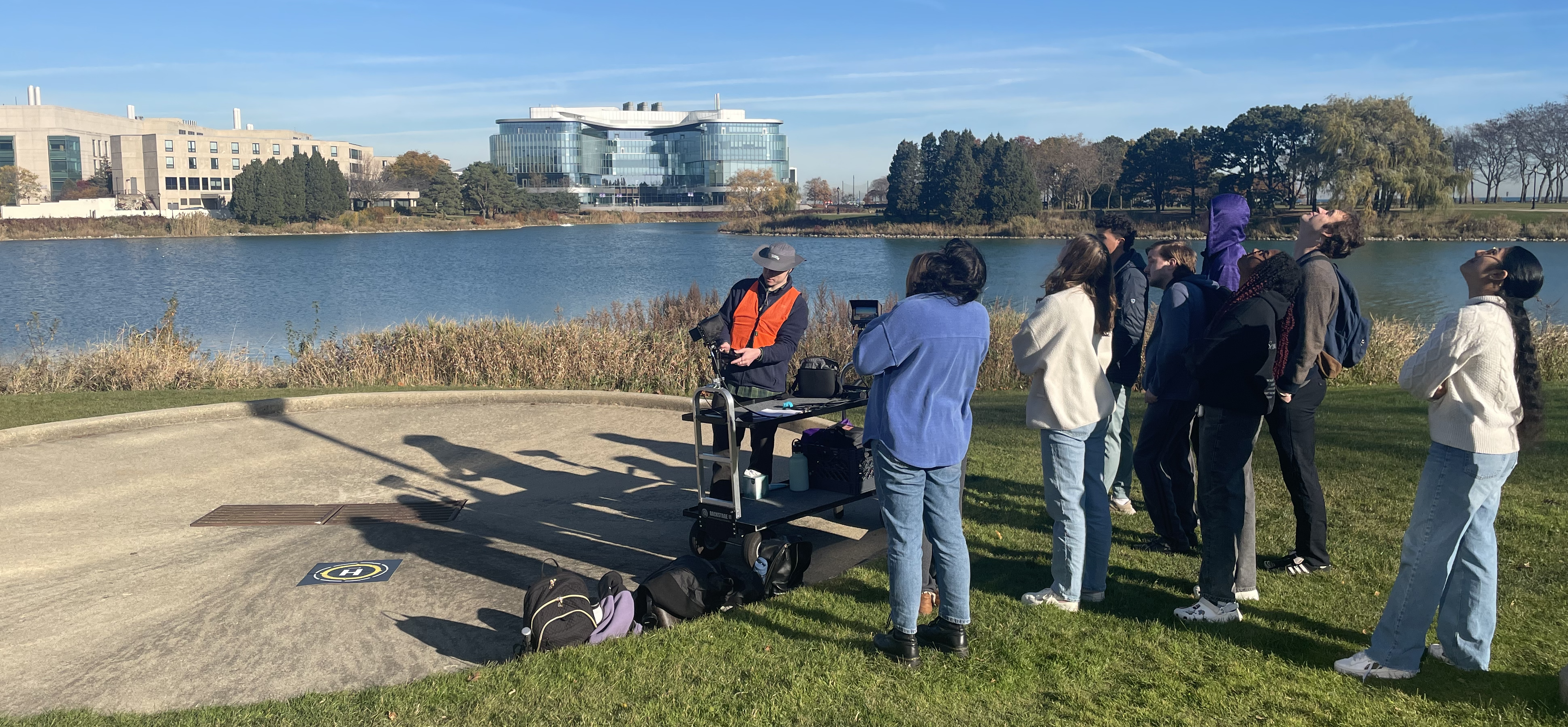
Lab participants spotting the drone after the instructional launch.
The collaboration with the Anthropology department is set to continue, with plans in the works to regularly offer this lab activity for the Archaeology: Unearthing History course. Moreover, there is a commitment to finding ways to integrate digital technologies into other course topics, expanding the horizons of archaeological survey and activity areas analysis.
Through this, the ripples of our experiment extended far beyond the Lakefill. Looking ahead, the future holds exciting prospects. Students will have the opportunity to deepen their analytical skills, explore cutting-edge equipment, and delve into the dynamic relationship between technology, data collection, and analysis. As we reflect on the lessons learned, the Media and Technology Innovation team gained valuable insights into student engagement and reaffirmed the potential of drone survey strategies in education and historic preservation.
This rewarding collaboration has allowed the Media and Technology Innovation team to demonstrate the usefulness of emerging technologies for the benefit of Northwestern students, staff, and faculty. As we soar into the future of virtual and immersive experience, we hope this lab experience will be a beacon of inspiration for other departments across the campus to embrace technology and provide dynamic, entertaining and educational experiences for our incredible learning communities.